
Coastal Recreational Use Classification Framework
I have developed a conceptual way to look at and classify the coast from an environmental and recreational perspective which should be useful for coastal planners and managers. The text explains this classification framework, how it was developed and gives several examples of its application.
You can also click here to download and read a pdf version of this.
To see examples of coastal areas that have been classified click on the links below - otherwise, read on:
Apollo Bay (2023); and
Context and history
The importance of the coast, including beaches and the nearshore marine area, as an outdoor recreation resource has been highlighted in a number of studies. As noted by Telses da Mota et al “Beaches are one of the most popular destinations for tourism and recreation globally.” (Teles da Mota, Pickering and Chauvenet 2022, 1).
Moreton Bay Regional Council’s Outdoor Recreation Plan (Ross Planning 2019) noted that the beach and ocean was the most popular location for outdoor recreation with 27% of residents saying they recreated at the coast, 15% saying they recreated at local reserves, and 14% at National Parks.
A study of Queensland beaches in 2013 estimated that the total annual local recreational value of those beaches was $1.6 billion(Windle and Rolfe 2013). A study of four of the beaches in Australia used modelling to estimate the annual value of resident recreation and tourism expenditure at those beaches, which is summarised in Table 1 below.
Table 1: Estimated annual value of resident recreation and tourism expenditure at selected beaches (Source: Raybould et al. 2013).

In 2018, the Centre for Sport and Recreation Research (CSRR) at Curtin University was commissioned to carry out a study of Perth’s beaches to provide a baseline understanding of recreational use of the Perth coastline. The report, titled “Perth Coastal Recreational Use Study”, was released in October 2018 (Middle, Tye and Middle 2018) and contained two main elements:
Coastal Recreational Use Audit which mapped the paths, infrastructure, location of special uses and designated uses areas; and
A Coastal Recreational Use Classification Framework and associated mapping.
Figure 1 (over the pages) is an example of the Coastal Recreational Use Audit maps produced in that report.
Figure 1: An example of a Coastal Recreational Use Audit in the original Perth Coastal Recreational Use Study (Source: Middle, Tye and Middle 2018)

The Coastal Recreational Use Classification Framework is a way of conceptualising the coast as a recreational and environmental resource. The framework identified two broad types of coastal locations: nodes and connectors.
Nodes are developed areas within a foreshore reserve that have infrastructure to allow for a range of passive and active recreation activities. Connectors are those areas of the foreshore that act as links between nodes.
The report identified a hierarchy of nodes depending on the amount of development and infrastructure present. The nodes were:
Beach access nodes which provide for only beach and water-based uses;
Minor activity nodes which provide additional park-based active and passive uses, with greater capacity for specialist water-based use;
Moderate activity nodes which provide a greater variety of park-based recreation, including commercial and indoor uses, however may restrict specialist water- based uses;
Major activity nodes – provide more extensive commercial opportunities and are typically used for tourism purposes;
Boat harbour nodes – facilitate many specialist water- based (boating) uses, however can restrict many water, beach and park-based uses.
The report identified the following recreational use connector categories:
Wild connectors – have limited beach and water- based recreation, however may provide unique aesthetic, nature and wilderness experiences;
Dune path connectors – permit greater access to the beach and typically contain shared paths and supporting infrastructure that facilitate a range of additional recreational uses, along with enhanced aesthetic and educational experiences; and
Urban connectors – have enhanced water and beach and path-based uses, however have negligible nature and wilderness experiences.
Figure 2 is a map of how the northern coast of Perth was categorised under this framework.
Figure 2: Categorisation of the northern coast of Perth under the Coastal Recreational Use Classification Framework (Source Middle, Tye and Middle 2018)

The Framework was further refined following work done for the NSW Central Coast Council (Middle and Middle 2023b, 2023a) and opportunistic visits to other coastal areas not typical of those in the above three studies.
The NSW Central Coast Council studies led to the addition of two types of connectors not found in Perth. In late 2023, Apollo Bay in Victoria was visited as it represented a coast outside a major metropolitan area, which led to a further two types of connectors being identified, both set in a rural landscape.
Below is the description of the final Coastal Recreational Use Classification Framework including photographs to illustrate each location type.
Whilst the main purpose was to classify the coast, it was also successfully applied to lakes and rivers.
The Framework was further refined following work done for the NSW Central Coast Council (Middle and Middle 2023b, 2023a) and opportunistic visits to other coastal areas not typical of those in the above three studies.
The NSW Central Coast Council studies led to the addition of two types of connectors not found in Perth. In late 2023, Apollo Bay in Victoria was visited as it represented a coast outside a major metropolitan area, which led to a further two types of connectors being identified, both set in a rural landscape.
The Coastal Recreational Use Classification Framework
As noted above coastal locations can be categorised into two broad types of coastal locations - nodes and connectors.
Nodes
Nodes are developed areas within a foreshore reserve that have a variety of infrastructure to allow for a range of passive and active recreation activities. These are placed where people stop and recreate. At a minimum, nodes provide access to the coast for both beach and water-based use, and may provide additional recreational opportunities away from the beach. Nodes range from being relatively small with few facilities – e.g. a small car park and a shower – to large nodes with multiple facilities and commercial premises (cafes etc.). The extent of the development at a node is one key determiner of the number of visitors to the site and also where they come from (i.e. the node’s catchment). Small nodes primarily serve the local community, and visitor numbers are relatively low. Larger nodes that have many more facilities including commercial premises attract visitors from outside the local area. Larger nodes may attract tourists from outside region – i.e. statewide, nationally and internationally.
One node type is port or industry related with little if any public access to the coast. Another is boating facilities node, where the prime use is boat storage and launching, and public access is still allowed.
Connectors
Connectors are those areas of foreshore that act as links between two nodes. They have few if any infrastructure other than a formal path, the occasional lookout as well as track access to the beach, although in more remote areas the path is absent. Connectors have a range of values, including ecosystem, recreation, aesthetic, wildlife corridors, and, where there is no foreshore reserve, private economic. The foreshore away from urban areas can be dominated by natural vegetation, but in more built up areas the foreshore is much narrower and can have extensive grassed areas. Visitors typically pass through these areas either to exercise (walk, run, walking the dog etc.) or to access adjacent beaches or nodes, but may also stop for a short time and use specific infrastructure (e.g. lookouts) for passive recreational purposes.
One type of connector has private property up to the high water mark which does not allow public access.
Access points
Connectors often have tracks or path that provide public access to the beach, usually from roads, but with no infrastructure. These are called beach access points and are not considered nodes.
Summary of Coastal Recreational Use Classification Framework
Table 1 summarises the framework. Section 3 has photographs of examples of each type of node, connector and access point.
Table 1: The Coastal Recreational Use Classification Framework


Example of access points, nodes and connectors
Access points

Types of nodes
Beach access nodes

Minor activity nodes

Moderate Activity Nodes

Major activity nodes

Boating facilities

Port and industry

Connectors
Conservation connectors

Landscape connectors

Shared path connectors

Urban connector

Local connectors

Residential connectors

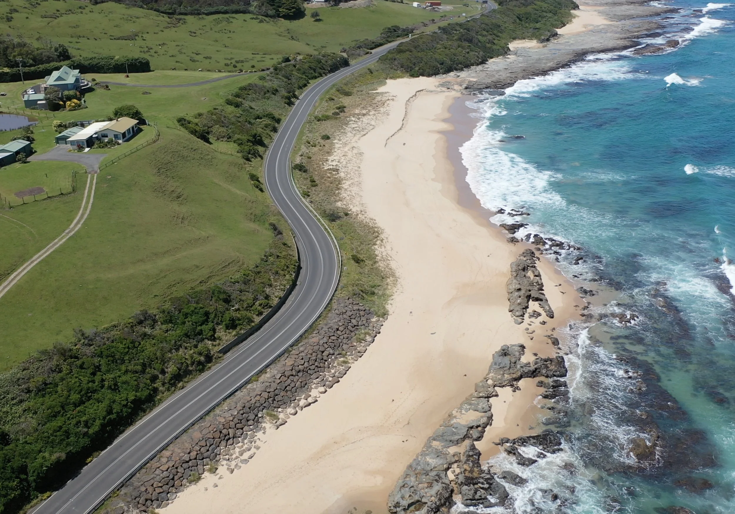
Rural residential connector

Rural beach connector
Rural conservation connector

Completed coastal classification mapping
As noted above, classification of the following coasts has been carried out:
Apollo Bay (2023); and
The framework, the maps and associated legends have evolved over time, and are not always consistent with each other. Click on those live links to see those maps.